Aug 7, 2023
Crop science aided by drones flying over fields
Unmanned aerial vehicles UAVs – or drones – possess many professional uses. he The American Society of Agronomy and Crop Science Society of America wants growers to know how the new world of drones aid crop science research.
With drone advancements and lower costs, drones have become more common in the daily activities of crop science research. They can replace the hard work of walking through fields, taking measurements and identifying problems. They help scientists accelerate discoveries and reduce labor costs to create more nutritious, high-yielding, and flavorful crops.
Before delving into examples and applications, let’s talk about the fundamental concept grounding how drones are used in crop science. Our Sun emits radiation, which we call the “electromagnetic spectrum.” This includes the visible light that we see and also microwaves, near infrared waves, x-ray, and gamma-rays.
We can “see” different parts of the spectrum by attaching specific sensors to drones, just like wearing night vision goggles to detect the heat of people hiding in the woods. By using sensors and drones, we can 1) distinguish plants from their surroundings and 2) capture images of the inner workings of crops.
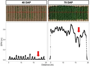
When you see a child that is very tall compared to other kids, you may think “future basketball star.” In crop science, we want to be able to look out over a field and predict the yield at the end of the season.
For instance, let’s talk about potatoes. In Figure 1, a drone captured an image of a field of potatoes to measure plant height. It was possible to evaluate that some varieties were taller than others. Considering plant breeding, we expect that taller potato plants have more leaves and can produce more nutrients for the developing potatoes underground.
Just like you can tell that a person is looking pale and green in the face if they are sick, we can use drones to measure the health of plants. We can use drones and sensors to scan a field for the presence of crop diseases or low crop productivity, as shown in Figure 2.
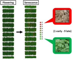
Even more impressive, a map of the location of unhealthy plants can be built to then guide a spraying drone so that pesticides or fertilizers can be applied specifically and directly to diseased plants. Research in crop science includes discovering which sensors and parts of the electromagnetic spectrum are useful for measuring plant health and even to distinguish specific crop diseases.
Telling different species of plants apart by eye is no easy feat. But we can use drones to distinguish weeds from crops. We can find weeds because different plant species use the energy from the Sun’s electromagnetic spectrum in different ways. Those differences can be detected using the sensors on drones.
Once weeds are detected, spraying drones now can be used to eliminate weeds in the field with targeted herbicide application. This targeted spraying is sustainable, reducing herbicide use, labor costs, human health, and environmental impacts.
The same principle for distinguishing weeds from crops can be used to differentiate individual plants in a breeding population to find the most promising for future breeding projects.
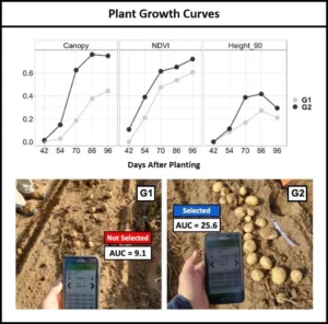
In Figure 3, drones captured data about different crops in a field: canopy (the size of the area covered with leaves), NDVI (a plant greenness and health indicator), and estimated plant height.
Combining these data, we could predict that variety 2 was better than variety 1 by their scores, even before harvesting. You can see the potatoes of variety 1 – on the left – are much smaller (notice the person’s feet for comparison on the left) than the potatoes of variety 2 on the right.
In the future, we see drones being used more and more by farmers and scientists to make people’s lives easier. With the reducing costs of drones, sensors, and tools to use the data, they will become more accessible worldwide. Now you know that at some point a drone was used to help make decisions to produce what you are eating.
To read more about research by Filipe Matias, Syngenta, and Jennifer Lachowiec, Montana State University, view their paper in Crop Science, a publication of the Crop Science Society of America.
This blog is sponsored and written by members of the American Society of Agronomy and Crop Science Society of America. The organizations’ members are researchers and trained, certified, professionals in the areas of growing the world’s food supply while protecting the environment. The organizations work at universities, government research facilities, and private businesses across the U.S. and the world.
-Story and images courtesy of the American Society of Agronomy and Crop Science Society of America.

